



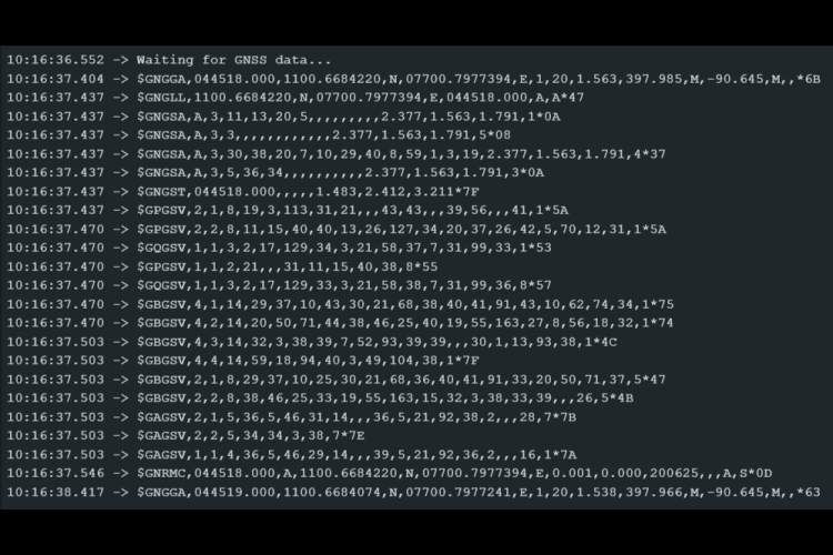
#define GPSSerial  Serial
#define DEBUGSerial Serial
void setup()
{
GPSSerial.begin(115200);
DEBUGSerial.begin(115200);
DEBUGSerial.println("Waiting for GNSS data...");
}void loop()
{
while (GPSSerial.available()) {
DEBUGSerial.write(GPSSerial.read());
}
}
#define GPSSerial Serial
#define DEBUGSerial Serial
const unsigned long PRINT_INTERVAL = 1000;
// GNSS Data
String utcTime = "--:--:--";
String localTime = "--:--:--";
String latitude = "--";
String longitude = "--";
String altitude = "--";
String fixQuality = "--";
String speedKmh = "--";
// Satellite Signal Info
int gpsCount = 0, beidouCount = 0, galileoCount = 0, qzssCount = 0, glonassCount = 0;
String snrList = "";
String nmeaBuffer = "";void setup() {
GPSSerial.begin(115200);
DEBUGSerial.begin(115200);
DEBUGSerial.println("Waiting for GNSS data...");
}void loop() {
readGNSSData();
static unsigned long lastPrint = 0;
if (millis() - lastPrint >= PRINT_INTERVAL) {
lastPrint = millis();
printGNSSInfo();
resetCounters();
}
}void readGNSSData() {
while (GPSSerial.available()) {
char c = GPSSerial.read();
if (c == '\n') {
processNMEALine(nmeaBuffer);
nmeaBuffer = "";
} else if (c != '\r') {
nmeaBuffer += c;
}
}
}void processNMEALine(const String &line) {
if (!line.startsWith("$")) return;
if (line.startsWith("$GPGSV") || line.startsWith("$GBGSV") ||
line.startsWith("$GAGSV") || line.startsWith("$GQGSV") ||
line.startsWith("$GLGSV")) {
parseGSVLine(line);
} else if (line.startsWith("$GNRMC")) {
parseRMC(line);
} else if (line.startsWith("$GNGGA")) {
parseGGA(line);
}
}void parseRMC(const String &line) {
int commas[13], idx = -1;
for (int i = 0; i < 13; i++) {
idx = line.indexOf(',', idx + 1);
if (idx == -1) break;
commas[i] = idx;
}
if (commas[1] - commas[0] > 1) {
String rawTime = line.substring(commas[0] + 1, commas[1]);
int hour = rawTime.substring(0, 2).toInt();
int minute = rawTime.substring(2, 4).toInt();
int second = rawTime.substring(4, 6).toInt();
utcTime = formatTime(hour, minute, second);
// Local time adjustment (+5:30)
minute += 30;
if (minute >= 60) {
minute -= 60;
hour += 1;
}
hour = (hour + 5) % 24;
localTime = formatTime(hour, minute, second);
}
if (commas[7] > commas[6]) {
float knots = line.substring(commas[6] + 1, commas[7]).toFloat();
speedKmh = String(knots * 1.852, 1);
}
}void parseGGA(const String &line) {
int commas[15], idx = -1;
for (int i = 0; i < 15; i++) {
idx = line.indexOf(',', idx + 1);
if (idx == -1) break;
commas[i] = idx;
}
String latVal = line.substring(commas[1] + 1, commas[2]);
String latDir = line.substring(commas[2] + 1, commas[3]);
String lonVal = line.substring(commas[3] + 1, commas[4]);
String lonDir = line.substring(commas[4] + 1, commas[5]);
latitude = convertLatLon(latVal, latDir);
longitude = convertLatLon(lonVal, lonDir);
fixQuality = line.substring(commas[5] + 1, commas[6]);
altitude = line.substring(commas[8] + 1, commas[9]) + " m";
}String convertLatLon(const String &val, const String &dir) {
if (val.length() < 4) return "--";
int degLen = (dir == "N" || dir == "S") ? 2 : 3;
float degrees = val.substring(0, degLen).toFloat();
float minutes = val.substring(degLen).toFloat();
float decimal = degrees + (minutes / 60.0);
if (dir == "S" || dir == "W") decimal *= -1;
return String(decimal, 6);
}String formatTime(int h, int m, int s) {
char buffer[9];
sprintf(buffer, "%02d:%02d:%02d", h, m, s);
return String(buffer);
}
String describeFixQuality(const String &code) {
if (code == "0") return "0 → Not fixed";
if (code == "1") return "1 → Standalone";
if (code == "2") return "2 → DGPS Fix";
if (code == "3") return "3 → PPS Fix";
if (code == "4") return "4 → RTK Fixed";
if (code == "5") return "5 → RTK Float";
return code + " → Unknown";
}void parseGSVLine(const String &line) {
if (line.startsWith("$GPGSV")) gpsCount += countSatellitesInLine(line);
else if (line.startsWith("$GBGSV")) beidouCount += countSatellitesInLine(line);
else if (line.startsWith("$GAGSV")) galileoCount += countSatellitesInLine(line);
else if (line.startsWith("$GQGSV")) qzssCount += countSatellitesInLine(line);
else if (line.startsWith("$GLGSV")) glonassCount += countSatellitesInLine(line);
int fieldStart = 0, fieldEnd = 0, fieldCount = 0;
while ((fieldEnd = line.indexOf(',', fieldStart)) != -1) {
String field = line.substring(fieldStart, fieldEnd);
fieldStart = fieldEnd + 1;
fieldCount++;
if (fieldCount >= 7 && ((fieldCount - 7) % 4 == 0)) {
appendSNR(field);
}
}
fieldEnd = line.indexOf('*');
if (fieldEnd != -1 && fieldStart < fieldEnd) {
appendSNR(line.substring(fieldStart, fieldEnd));
}
}int countSatellitesInLine(const String &line) {
int count = 0, idx = -1;
for (int i = 0; i < 20; i++) {
idx = line.indexOf(',', idx + 1);
if (idx == -1) break;
if (i >= 4 && (i - 4) % 4 == 0) count++;
}
return count;
}
void appendSNR(const String &field) {
if (field.length() > 0 && isDigit(field[0])) {
int snr = field.toInt();
if (snr > 0 && snr <= 99) {
snrList += String(snr) + " dB ";
}
}
}void summarizeSNR() {
int excellent = 0, good = 0, fair = 0, weak = 0, invalid = 0;
int start = 0;
while (start >= 0 && start < snrList.length()) {
int end = snrList.indexOf(" dB", start);
if (end == -1) break;
int val = snrList.substring(start, end).toInt();
if (val >= 40) excellent++;
else if (val >= 30) good++;
else if (val >= 20) fair++;
else if (val >= 1) weak++;
else invalid++;
start = snrList.indexOf(" ", end);
if (start == -1) break;
start += 2;
}
DEBUGSerial.println("---- Signal Strength Summary ----");
DEBUGSerial.print("Excellent (≥40 dB) : "); DEBUGSerial.println(excellent);
DEBUGSerial.print("Good (30–39 dB): "); DEBUGSerial.println(good);
DEBUGSerial.print("Fair (20–29 dB): "); DEBUGSerial.println(fair);
DEBUGSerial.print("Weak (1–19 dB) : "); DEBUGSerial.println(weak);
DEBUGSerial.print("Invalid (0 or N/A) : "); DEBUGSerial.println(invalid);
}void printGNSSInfo() {
DEBUGSerial.println("\n====== GNSS INFO ======");
DEBUGSerial.print("Fix Quality: "); DEBUGSerial.println(describeFixQuality(fixQuality));
if (fixQuality != "0" && fixQuality != "") {
DEBUGSerial.print("UTC Time : "); DEBUGSerial.println(utcTime);
DEBUGSerial.print("Local Time : "); DEBUGSerial.println(localTime);
DEBUGSerial.print("Latitude : "); DEBUGSerial.println(latitude);
DEBUGSerial.print("Longitude : "); DEBUGSerial.println(longitude);
DEBUGSerial.print("Speed : "); DEBUGSerial.print(speedKmh); DEBUGSerial.println(" km/h");
DEBUGSerial.print("Altitude : "); DEBUGSerial.println(altitude);
} else {
DEBUGSerial.println("UTC Time : --");
DEBUGSerial.println("Local Time : --");
DEBUGSerial.println("Latitude : --");
DEBUGSerial.println("Longitude : --");
DEBUGSerial.println("Speed : --");
DEBUGSerial.println("Altitude : --");
}
DEBUGSerial.println("---- Satellites Visible ----");
DEBUGSerial.print("GPS(USA) : "); DEBUGSerial.println(gpsCount);
DEBUGSerial.print("BeiDou(China) : "); DEBUGSerial.println(beidouCount);
DEBUGSerial.print("Galileo(Europe) : "); DEBUGSerial.println(galileoCount);
DEBUGSerial.print("QZSS(Japan) : "); DEBUGSerial.println(qzssCount);
DEBUGSerial.print("GLONASS(Russia) : "); DEBUGSerial.println(glonassCount);
summarizeSNR();
DEBUGSerial.println("===================================");
}void resetCounters() {
gpsCount = beidouCount = galileoCount = qzssCount = glonassCount = 0;
snrList = "";
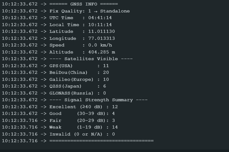
}

Projets liés aux modules GNSS
#define GPSSerial Serial
#define DEBUGSerial Serial
void setup()
{
 GPSSerial.begin(115200);
 DEBUGSerial.begin(115200);
 DEBUGSerial.println("Waiting for GNSS data...");
}
void loop()
{
 while (GPSSerial.available()) {
    DEBUGSerial.write(GPSSerial.read());
 }
}Retrouvez l’histoire de Raspberry Pi dans cette vidéo :

-
 Quystetes 1 Pièce GM906BT L1 L5 Support Agricole Android Bluetooth USB GPS GNSS Récepteur Module D'Antenne 5V Débit en Bauds 115200 Noir
 -
 Meshnology Wio Tracker L1 SX1262 nRF52840 Lot de 2 cartes de développement pour Arduino Meshtastic LoRa, Blue Tooth 5, GPS GNSS 1,3", OLED, prend en charge la batterie de type C et la charge solaire